Mapping the Solar Potential of Every Rooftop
The engineering company CH2M Hill is now joining hands with the U.S. Department of Energy to provide Internet solar maps of 25 American cities, using Google Earth technology to chart the precise solar potential of neighborhoods, literally rooftop by rooftop. The company has just finished mapping all of San Francisco, allowing residents to enter their address and take the solar measure of their own home. "People in San Francisco think we don't have any solar potential,' says Gavin Newsom, the city's deep-green mayor. "But the map shows we have a lot more sun than you'd believe." Time Magazine Source.
Comments (0)
This post does not have any comments. Be the first to leave a comment below.
Featured Product
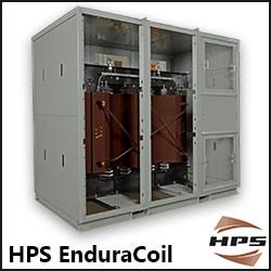
HPS EnduraCoilTM Cast Resin Medium Voltage Transformer
HPS EnduraCoil is a high-performance cast resin transformer designed for many demanding and diverse applications while minimizing both installation and maintenance costs. Coils are formed with mineral-filled epoxy, reinforced with fiberglass and cast to provide complete void-free resin impregnation throughout the entire insulation system. HPS EnduraCoil complies with the new NRCan 2019 and DOE 2016 efficiency regulations and is approved by both UL and CSA standards. It is also seismic qualified per IBC 2012/ASCE 7-10/CBC 2013. Cast resin transformers are self-extinguishing in the unlikely event of fire, environmentally friendly and offer greater resistance to short circuits. HPS also offers wide range of accessories for transformer protection and monitoring requirements.